
Beyond Bridges - Trail Maintenance
Meet the high-tech bicycle mapping Indiana trails
April 11, 2024 | South Bend, Ind.
By Scott Palmer, Indiana Public Broadcasting
Listen to radio version:
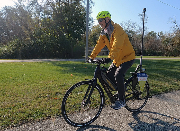
Outdoor enthusiasts in North Central Indiana may have noticed a strange-looking bicycle on their local trails lately.
It's usually the pole that catches their attention. It rises several feet in the air just behind the rider, with a 360-degree camera mounted on top. Another camera is mounted at the pole's base just over the rear wheel.
On either side of that wheel, two colorful signs provide a helpful explanation: this aptly named “data bike” uses technology to capture 360-degree imagery and other information about pavement roughness.
While the high-tech bike isn't intended for recreation or even commuting, its purpose is to help other trail users enjoy well-maintained trails for years to come. The bike, believed to be the first of its kind in Indiana, is a recent addition to the asset-management tools used by planners in the four-county area of Michiana.
Dustin New is one of those planners and the person you're most likely to see riding the bike. He's the Active Transportation Planner for the Michiana Area Council of Governments (MACOG), which collaborates with local cities and counties to resolve region-wide transit or development issues. New says his focus is non-motorized means of getting around - including bikes, scooters, and even walking.
What insight does the bike provide?
New explains what data the bike collects, starting with the 360-degree images captured by the pole-mounted camera.
“We'll get kind of a street view, if you will, of the trail. We're calling it the trail view,” New says. “And then it also has a camera on the back that shoots downward at certain intervals.”
Vehicle drivers who use navigation apps like Google Maps will recognize the similarity between the data bike and the well-known Google Street View vehicle, which captures comparable driver's-eye views of roadways.
But the key piece, New says, is the unassuming smartphone mounted to the bike's frame right on the downtube where most bikes sport a water bottle.
“As you're riding along the trail, you hit bumps, the phone vibrates,” New explains. “It records that as an anomaly in the road, or in the trail.”
The app displays a graph while the bike is being ridden, reflecting the condition of the trail surface. Watching the graph is like watching an EKG tick off a heartbeat - except each heartbeat here is a bump sensed by the phone. The bigger the pothole, for example, the bigger the spike in the graph.
“The idea is that we can then develop a GIS map where you can see the condition of the trails graphically,” New explains. “And you could literally look at a photograph of what created that rough condition.”
MACOG's first goal is to establish a baseline set of data, assessing current conditions within the 160 miles of trails throughout the region's four counties. The data will also reflect the status of trailside amenities such as benches, signs, or bike racks.
Not every bump is a pothole, of course. It could be a change in pavement from gravel to concrete. Or temporary debris following a storm. “Whatever it may be,” New adds, the data and images can be used to evaluate that condition, “and decide if it needs to be fixed immediately.”
Or if the condition doesn't warrant immediate attention, the data can assist longer-term maintenance planning - which includes a key event New hopes to see more often.
“And then develop a budget for it,” New says.
How trail maintenance is funded
While statewide funding for the construction of trails has been celebrated throughout Indiana recently, funding for the routine upkeep of those trails is harder to come by.
New hopes the data bike will help close that gap within the four-county area MACOG serves.
“Each of the communities within that area, and/or counties, has responsibilities for maintaining their trails,” New says. “There may be, but I'm not aware of any community that has a budget item or a line item for trail maintenance. And that's the problem.”
State and federal programs fund development
State and federal matching grant programs are the most common funding sources for initial trail construction. Such high-level investment is unsurprising, considering the price of trail development: building a single mile of new trail can cost between $800,000 and $1.2 million depending on how it's built.
Since 2019, Indiana's Next Level Trails program has invested $180 million to develop more than 217 miles of trails in 58 counties. It's the largest infusion of state funding for trails in Indiana's history. The program has funded 89 trail projects so far, favoring projects that make connections between other trails or communities.
The program represents significant progress toward Indiana's vision for the future: a system of interconnected trails across the entire state.
Meanwhile, trails remain local projects
The visibility of high-profile matching grant programs can lead to misunderstandings about who is ultimately responsible for trail projects.
“Where the actual trails go,” New explains, “is generally going to be a local decision and pushed by the local community.” Even if state or federal funds are available to build trails, maintaining those trails once they are built also remains a local responsibility.
The estimated cost to maintain a single mile of trail can vary from $1,000 to $10,000 per mile, per year. That means a community with 50 miles of trails should - ideally - set aside between $50,000 and $500,000 per year for trail upkeep.
Asking a community to incur that expense is usually a tough sell. “It's always [that] something has to be given up somewhere else in a budget to make that happen. And nobody wants to give up any portion of their budget,” New explains.
“So [maintenance] kind of gets deferred, and pretty soon you end up with trails that are not in good shape and not being used as much as they could,” he adds.
The issue is not new, nor is it local. A decade ago, the Ohio River Greenway called deferred trail maintenance “a nationwide issue,” ranking among the top concerns of Indiana trail users in a more recent study by Indiana University. According to a 2014 report by a bicycle advocacy partnership, the burden of trail maintenance is often onerous enough to dissuade some local communities from pursuing new trail projects at all, even though the project's construction costs may be secured.
A data-driven idea: prioritize trails like roads
The new data bike signals a creative approach to the issue. By borrowing asset-management practices already in use for roadways, MACOG hopes to tee up trails for similar budgeting attention - and for similar reasons.
“MACOG looks at trails as an asset to the community,” New explains. “And part of what is typically done with roadways, for instance, is communities have an asset management plan to kind of quantify the condition of their roadways. We have the thought that that could be applied to trails as well, but we needed a way to do that.”
While the bike's pavement-roughness data supports that effort, it's not the only data that does. MACOG already has data on trail usage, thanks to several sensors located throughout the system.
The sensors, which look like ordinary trailside posts, count trail users as they pass by. Additional sensors within the trail surface can distinguish cyclists from pedestrians -- making it easy to see that many trail users are indeed commuters.
“There are upticks in the time of day that we have the most traffic. It's mornings and afternoons when people are going to work, and people are coming home from work,” New explains. “It's not all recreational. And that's kind of the approach that we're starting to take, is that if you plan trails for people to commute on, you get both benefits without having to just focus on one.”
New believes the data-driven approach could help unlock new sources of funding for trail maintenance.
“Just like the asset management plans can be used to develop budgets from highway dollars, whether it be federal or state, we think you should be able to utilize those same pools of money to maintain your trails in your community,” New says.
If you build it, will they commute?
New knows how trails can help remove cars from roads, and he hopes to see the shift toward active transportation continue. “70% or more of trips in a car are three miles or less. That's a pretty easy trip to do on a bike,” he says.
“So that's kind of the goal, is to try and get people to see the opportunity. And then you've also got to create the opportunity. Trails are the opportunity to give people to use something other than their car.”
Join the discussion on Faceboook
Links
- Indiana Next Level Trails
- Indiana Next Level Trails Grant Awards - Map
- Indiana Next Level Trails Progress Dashboard
- Indiana Next Level Trails Application Handbook
- Indiana Trails Program
- Indiana Trails Program Manual 2023 - 2024
- Indiana Statewide Comprehensive Outdoor Recreation Plan 2021-2025
- Indiana Trail Counters
- Regional Planning Councils Membership Directory
- MACOG GIS data dashboards
- Indy MPO Active Transportation Plan
- Greenways Foundation of Indiana
- Indiana Trails Fund
- Indiana Trails
Beyond Bridges, a new series of articles and short documentaries on Indiana Infrastructure, is a collaboration between Indiana Public Broadcasting and PBS Michiana - WNIT.
Scott Palmer is a freelance producer and correspondent for Indiana Public Broadcasting and PBS Michiana - WNIT.